NE WIND 5 TO 10 KT...BECOMING N 10 TO 15 KT IN THE AFTERNOON.
WIND WAVES 2 FT.
W SWELL 6 FT AT 12 SECONDS.
BUILDING TO W SWELL 7 FT AT 13 SECONDS.
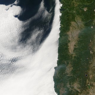
"A smooth layer of low-lying clouds seeps into the bays, low-lying coves, and waterways of the northwestern United States in this image captured by the Moderate Resolution Imaging Spectroradiometer (MODIS) on NASA’s Aqua satellite on September 29, 2006. Lining the coast, the pine-covered Coast Ranges hold the clouds back so that skies over the Pacific Northwest are clear. The stunning contrast between cloudy and clear skies is driven by the Earth’s rotation.
As the Earth spins on its axis, the movement pushes ocean surface waters west away from the western edge of continents. In a process called upwelling, cool water from deep in the ocean rises to replace the surface water. Upwelling creates a layer of cool water at the surface, which cools the air immediately above the water. As the moist, marine air cools, water vapor condenses into water droplets, and low clouds form. These lumpy, sheet-like clouds are marine stratocumulus clouds, and they are a common occurrence along the western coasts of the continents, where upwelling is common. Probably no higher than a kilometer (about 3,000 feet) above the Earth’s surface, the clouds in the image hug the coastline in echo of the cool ocean currents beneath them. In contrast, warm, dry air dominates over land, keeping skies cloud free".
~from 'The Professor' via NASA


0 comments:
Post a Comment